Jacksonville's early predominant position as a regional center of business left an indelibly mark on the city's skyline. Many of the earliest skyscrapers in the state were constructed in Jacksonville, dating as far back as 1902.,[48] The city last held the state height record from 1974 to 1981.[49] The tallest building in Downtown Jacksonville's skyline is the Bank of America Tower, constructed in 1990 as the Barnett Center. It has a height of 617 ft (188 m) and includes 42 floors.[50][51] Other notable structures include the 37-story Wells Fargo Center (with its distinctive flared base making it the defining building in the Jacksonville skyline),[52][53] originally built in 1972-74 by the Independent Life and Accident Insurance Company, and the 28 floor Riverplace Tower which, when completed in 1967, was the tallest precast, post-tensioned concrete structure in the world.[54][55]
-
 Laura Street Trio (1902-1912)
-
 The Carling (1925)
-
 11 East Forsyth (1926)
-
 Aetna Building (1955)
-
 Riverplace Tower (1967)
-
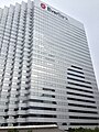
 Wells Fargo Center (1974)
-
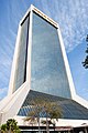
 EverBank Center (1983)
-
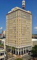
 Bank of America Tower (1990)


Climate

On October 7, 2016, Hurricane Matthew threatened the First Coast region.
| Jacksonville | ||||||||||||||||||||||||||||||||||||||||||||||||
|---|---|---|---|---|---|---|---|---|---|---|---|---|---|---|---|---|---|---|---|---|---|---|---|---|---|---|---|---|---|---|---|---|---|---|---|---|---|---|---|---|---|---|---|---|---|---|---|---|
| Climate chart (explanation) | ||||||||||||||||||||||||||||||||||||||||||||||||
|
||||||||||||||||||||||||||||||||||||||||||||||||
|
||||||||||||||||||||||||||||||||||||||||||||||||
Mean monthly temperatures range from around 53 °F (12 °C) in January to 82 °F (28 °C) in July. High temperatures average 64 to 92 °F (18 to 33 °C) throughout the year.[57] High heat indices are common for the summer months in the area, with indices above 110 °F (43.3 °C) possible. The highest temperature recorded was 104 °F (40 °C) on July 11, 1879 and July 28, 1872.[58] It is common for thunderstorms to erupt during a typical summer afternoon. These are caused by the rapid heating of the land relative to the water, combined with extremely high humidity.
During winter, there can be hard freezes during the night. Such cold weather is usually short lived, as the city averages only 10 to 15 nights at or below freezing and around 5 days where the high does not rise above 50 °F (10 °C).[59] The coldest temperature recorded at Jacksonville International Airport was 7 °F (−14 °C) on January 21, 1985. Jacksonville has recorded three days with measurable snow since 1911, most recently a one-inch snowfall in December 1989[60] and flurries in December 2010.[61]
Jacksonville has suffered less damage from hurricanes than most other east coast cities, although the threat does exist for a direct hit by a major hurricane. The city has only received one direct hit from a hurricane since 1871; however, Jacksonville has experienced hurricane or near-hurricane conditions more than a dozen times due to storms crossing the state from the Gulf of Mexico to the Atlantic Ocean, or passing to the north or south in the Atlantic and brushing past the area.[62] The strongest effect on Jacksonville was from Hurricane Dora in 1964, the only recorded storm to hit the First Coast with sustained hurricane-force winds. The eye crossed St. Augustine with winds that had just barely diminished to 110 mph (180 km/h), making it a strong Category 2 on the Saffir-Simpson Scale. Jacksonville also suffered damage from 2008's Tropical Storm Fay which crisscrossed the state, bringing parts of Jacksonville under darkness for four days. Similarly, four years prior to this, Jacksonville was inundated by Hurricane Frances and Hurricane Jeanne, which made landfall south of the area. These tropical cyclones were the costliest indirect hits to Jacksonville. Hurricane Floyd in 1999 caused damage mainly to Jacksonville Beach. During Floyd, the Jacksonville Beach pier was severely damaged, and later demolished. The rebuilt pier was later damaged by Fay, but not destroyed. Tropical Storm Bonnie would cause minor damage in 2004, spawning a minor tornado in the process.[63] On May 28, 2012, Jacksonville was hit by Tropical Storm Beryl, packing winds up to 70 miles per hour (113 km/h) which made landfall near Jacksonville Beach.
No comments:
Post a Comment